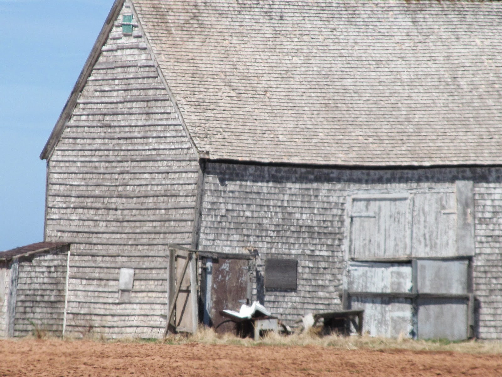
I took these photos of this old homestead on the TransCanada Highway in Belfast yesterday. Meacham's1880 Atlas shows this property belonging to Robt McWilliams (50 Ac) & Chas. & Jas McWilliams (52 Ac) - today it appears these two parcels are one. The low roof pitch and style makes me think this is a mid-1800's house. The house appears to be on the Chas. & Jas McWilliams portion.
In Cummins 1928 Atlas it show's Jno. R. McWilliams with 110 Ac. It notes that John is an Ex-Road Master; married to Catherine, with the following children: Marion, Margaret, Bruce, Florence and John.
This Blog is to inform and display the architectural heritage of Prince Edward Island!
Showing posts with label Meachams 1880 Atlas. Show all posts
Wednesday, March 1, 2017
Saturday, October 31, 2015
O'Connell-McCabe-O'Shea Store, Iona
The previous post in this blog show's this old country store in Iona being destroyed by fire yesterday. It was located at 1788 Iona Road where it intersects with the Selkirk Road.
According to CBC PEI News online today, the store was owned by Leo and Florence O'Shea who had operated O'Shea's Grocery here until 1993 and since it was not a store. The family also noted "...it had been in operation for 200 years."
Below are photos from Google Maps.
According to Meacham's 1880 Atlas of Prince Edward Island (see map below from the Atlas) the store was owned by Jno O'Connell with 2 acres and a Store.
In the Cumin's 1928 Atlas of Prince Edward Island, the store was owned by James McCabe with 10 acres. It notes he was married to Annie (Anastasia Cairns) with the following children: Annie, Mary, Margaret and Louise. According to the McCabe genealogy on the Island Register ( http://www.islandregister.com/mccabe1.html ) James' (1859-1942) daughter Mary J. (1897-1961) "...owned and ran the McCabe store in Iona."
Labels:
country store,
Cumins 1928 Atlas,
Fire,
Iona,
Meachams 1880 Atlas
Saturday, September 6, 2014
Gamester Homestead
I've been noticing this place the past few years, first the lawns weren't cut then a window was broken and last winter a curtain waved in the wind all winter.
This was the home of Lemuel and Janie (MacKinnon) Gamester, located on the Bungay Road (Rte. 251) in Hunter River.
Cumins 1928 Atlas of Prince Edward Island shows Geo. Gamester living here with 97-acres of land (in two parcels of land) - it notes his wife Janie and their children, Guy, Arthur, Viola and Lemuel.
Meachams 1880 Atlas of Prince Edward Island shows these two parcels of land belonging to Jno. Hickox and Pat Hughes.
This was the home of Lemuel and Janie (MacKinnon) Gamester, located on the Bungay Road (Rte. 251) in Hunter River.
Cumins 1928 Atlas of Prince Edward Island shows Geo. Gamester living here with 97-acres of land (in two parcels of land) - it notes his wife Janie and their children, Guy, Arthur, Viola and Lemuel.
Meachams 1880 Atlas of Prince Edward Island shows these two parcels of land belonging to Jno. Hickox and Pat Hughes.
The house is an Island-ell style farmhouse.
Labels:
Bungay Road,
Cumins 1928 Atlas,
Gamester,
Hickox.,
Hughes,
Hunter River,
Island-ell Style,
Meachams 1880 Atlas,
PEI Farmstead
Monday, August 25, 2014
Bagnall House, Bell's Pond, New Glasgow
On my way from Hunter River to New Glasgow on Route 13 yesterday I took a detour down to Bell's Pond ( often called Campbell's Pond ) - just before Rte. 224, I turned right on to Campbell's Road and drove in about a kilometer to the little one-lane bridge at Bell's Pond. When I got over the bridge I stopped and took the photograph below of the old Bagnall House, likely built in the 1860s. It has vinyl siding on it today, however, it retains much of its character defining elements such as its symmetry; small entry porch with eave returns; the five-bay second floor windows; the attic scotch-style dormer; and the single hung windows.
Today I'd call this area Campbell's Pond, New Glasgow, however, in Meacham's 1880 Atlas this area is known as Clyde Mill's (on the River Clyde), Lot 23. As late as the 1935 telephone directory lists Mrs. Mary Bagnall at Clyde Mill's.
It's amazing to think this view coming over the bridge is much as it would have looked 134 years ago when an illustration of it appeared in Meacham's Atlas - see that image below - this house is #9 as noted on the bottom of the illustration.
Today I'd call this area Campbell's Pond, New Glasgow, however, in Meacham's 1880 Atlas this area is known as Clyde Mill's (on the River Clyde), Lot 23. As late as the 1935 telephone directory lists Mrs. Mary Bagnall at Clyde Mill's.
It's amazing to think this view coming over the bridge is much as it would have looked 134 years ago when an illustration of it appeared in Meacham's Atlas - see that image below - this house is #9 as noted on the bottom of the illustration.
When I got to the end of the Campbell's Road (which this property is on the corner) I turned left on to Mount Tom Road, which is very close beside this house and farmyard. It feels as though you're in their yard but the road continues past the barns, down a little hill, then up a steep hill (probably Mount Tom) - a beautiful one-lane country road which comes out above the PEI Preserve Company on to Route 224, the New Glasgow Road.
In Meachams' 1880 Atlas of Prince Edward Island, Page 86, it shows William and Richard Bagnall owning 100-acres here.
In Cumin's 1928 Atlas of Prince Edward Island it shows Mrs. R.E. Bagnall living here with her three daughter, Ella, Nettie and Blanche. She had 126-acres.
* * * * * * * * * * * * * * * * * * * * * * * * * * * * * *
The following info cf. Lovell’s Prince
Edward Island Directory, 1871
Clyde Mills:
A small village in township No. 23, parish of Grenville, county of
Queen's. Population about 60. [foot note says " The post office is at New
Glasgow."]
Bagnall, Richard E. - of Bagnall & Son
BAGNALL, WILLIAM - J.P., Bagnall & Son(1) Crawford, rev. Donald - baptist |
Doucet, Lemange - joiner, farmer
Doucet, Peter - farmer Warren, John - head miller |
Saturday, July 26, 2014
Old Barn, Hope River - demolished
On July 3rd I noticed the windows had been taken out of this old barn and thought it must be in advance of demolition - so I took these photos. It's located on the St. Mary's Road (Rte 224) near the intersection with Simpson Mill Road.
Meacham's 1880 Atlas of Prince Edward Island shows this farmstead was 2 farms, to the right/west was Felix Murphy with 55-acres and the Hope River Post Office. The farm to the left/east belonged to Jno Hogan with 60-acres.
Cumin's 1928 Atlas of Prince Edward Island shows the two farms above now one farm owned by Leo Reid with 114-acres.
Above is the new house that belongs to this farmstead - the old barn is to the left. This house was built in 2003-2004 - it replaced the house below which was moved over to the east corner lot (at St. Mary's Rd and Broadway Rd.) of the farmstead, restored and sold.
The photo below was taken on Feb. 14, 2004 - it shows the original house (now the yellow house above) with the new house behind (beige house /w red roof above) and the demolished barn above, in the far left.
Labels:
Cummins 1928 Atlas of PEI,
Demolished,
Hope River,
Meachams 1880 Atlas,
PEI Barns,
PEI Farmhouses,
PEI Houses,
St. Ann's,
St. Mary's Road
Tuesday, July 15, 2014
Elite Seed Farm, former Ashley Homestead, Fox Island
Recently I was over to Fox Island in western Prince Edward Island. It's located at 269 Fox Island Rd., off Rte. 12, between Alberton and Cascumpec.
Cumin's 1928 Atlas of Prince Edward Island shows the Island belonging to Lowden Ashley with 182-acres. Lowden was married to Susan Lewis and had the following children: Rhodes, John, Gladys, Alvin, Elmer, Freda, Fred and Harold.
Lowden *Loudy* Huestis Ashley (1877-1953), son of John Butcher Ashley and Sarah Stapley Wallace married Susan *Susie* Lewis (1878-1947) in December 1898. They lived on the part of the Ashley farm and later purchased the west end of Fox Island from his uncle, Fred Wallace. Loudy and Susie then moved to Fox Island where they raised their family of eight. Loudy was a farm and fox rancher. Info cf. http://www.ancestraltrails.ca/
When I worked at Maplewood Manor, Alberton, in the summers of 1981-82, Gladys (Ashley) Bonyman was a resident - she was in her 80's. She often told us about growing up on Fox Island and recalled Mik'maq families coming back to the shores of the Island to spend the summers. One of her vivid memories was seeing a native woman giving birth.
See 2008 Guardian newspaper article below telling history of the seed farm which was established in 1962.
Cumin's 1928 Atlas of Prince Edward Island shows the Island belonging to Lowden Ashley with 182-acres. Lowden was married to Susan Lewis and had the following children: Rhodes, John, Gladys, Alvin, Elmer, Freda, Fred and Harold.
Lowden *Loudy* Huestis Ashley (1877-1953), son of John Butcher Ashley and Sarah Stapley Wallace married Susan *Susie* Lewis (1878-1947) in December 1898. They lived on the part of the Ashley farm and later purchased the west end of Fox Island from his uncle, Fred Wallace. Loudy and Susie then moved to Fox Island where they raised their family of eight. Loudy was a farm and fox rancher. Info cf. http://www.ancestraltrails.ca/
See 2008 Guardian newspaper article below telling history of the seed farm which was established in 1962.
Below: Front of house, facing Northeast.
The house is a "Fox House" style home, likely built just before WWI.
Below: northeast view from front of house looking towards Dock River and Alberton.
Below: Southeast side of house.
Below is a barn standing out by itself as you drive up to the property.
Below is an article from the Guardian newspaper six years ago about the Elite Seed Farm.
- Elite seed farm topic at
potato board meeting -
The
Guardian. By Nancy Willis. Published on February 27,
2008
P.E.I. Potato Board holds first of four Islandwide
annual meetings in Rollo Bay
ROLLO
BAY - The P.E.I. Potato Board held the first of its four Islandwide annual
meetings here Tuesday, where the future of the Fox Island Elite Seed Farm was
of key interest.
This industry owned seed farm has been a fundamental part of the Prince Edward Island potato world for more than half a century.
Unlike similar organizations that are nationally funded in the United States, or provincially backed in New Brunswick, the P.E.I. Potato Board is supported completely by local Island growers.
This year, it cost those producers $217,000 to keep it running and the board decided it was time to take it to the farmers and let them decide what to do with it.
For decades, the elite seed farm was an international showplace for visitors, and throughout its lifetime it has ensured commercial Island growers that a local source of clean seed would be available to them.
Now dramatic changes in the potato world, a decrease in the numbers of varieties allowed to be grown there and increased private ownership of seed worldwide have all contributed to the farm not making a profit for the last few decades. "A variety of factors are also at play, including lower production acreage than in the past; the implication of various regulatory scenarios; and lower virus levels in seed now, which translate into less demand for early generated seed,'' said staff member Mary Kay Sonier.
Although the farmers were presented with a variety of alternatives, no one was interested in getting rid of it. A few of the many options included maintaining the status quo; selling the property and getting out of early seed production, or continuing with nuclear seed production and trying to expand the varieties they are able to grow.
Keeping the farm going and maintaining it as a safety net for the industry future was clearly the chosen path. All seemed to agree that the percentage of their dues that went to keeping it running was relatively small, and that keeping it was to everyone's benefit.
"We now need to know what direction the growers would like to take because there is much to be done out there, and that will depend on the direction we choose,'' said board chairman Kevin MacIsaac.
"Well, I don't see anyone jumping up and down to say sell her and make cottage lots,'' said Eastern Kings farmer Boyd Rose. He suggested looking at opening up the variety restrictions and lowering the price of the seed they sell so it is more competitive with commercially available product.
This and a raft of other topics and issues will be discussed at meetings in Mill River Thursday afternoon, and Summerside Thursday night.
This industry owned seed farm has been a fundamental part of the Prince Edward Island potato world for more than half a century.
Unlike similar organizations that are nationally funded in the United States, or provincially backed in New Brunswick, the P.E.I. Potato Board is supported completely by local Island growers.
This year, it cost those producers $217,000 to keep it running and the board decided it was time to take it to the farmers and let them decide what to do with it.
For decades, the elite seed farm was an international showplace for visitors, and throughout its lifetime it has ensured commercial Island growers that a local source of clean seed would be available to them.
Now dramatic changes in the potato world, a decrease in the numbers of varieties allowed to be grown there and increased private ownership of seed worldwide have all contributed to the farm not making a profit for the last few decades. "A variety of factors are also at play, including lower production acreage than in the past; the implication of various regulatory scenarios; and lower virus levels in seed now, which translate into less demand for early generated seed,'' said staff member Mary Kay Sonier.
Although the farmers were presented with a variety of alternatives, no one was interested in getting rid of it. A few of the many options included maintaining the status quo; selling the property and getting out of early seed production, or continuing with nuclear seed production and trying to expand the varieties they are able to grow.
Keeping the farm going and maintaining it as a safety net for the industry future was clearly the chosen path. All seemed to agree that the percentage of their dues that went to keeping it running was relatively small, and that keeping it was to everyone's benefit.
"We now need to know what direction the growers would like to take because there is much to be done out there, and that will depend on the direction we choose,'' said board chairman Kevin MacIsaac.
"Well, I don't see anyone jumping up and down to say sell her and make cottage lots,'' said Eastern Kings farmer Boyd Rose. He suggested looking at opening up the variety restrictions and lowering the price of the seed they sell so it is more competitive with commercially available product.
This and a raft of other topics and issues will be discussed at meetings in Mill River Thursday afternoon, and Summerside Thursday night.
* * * * * * * * * * * * * * *
Below is the map from Meacham's 1880 Atlas of PEI showing Fox Island.
Labels:
Ashley,
Bonyman,
Cummins 1928 Atlas of PEI,
Elite Seed Farm,
Fox House,
Fox Island,
Meachams 1880 Atlas
Thursday, June 12, 2014
"Kilmahumaig" (Station of Meteorological Service), S. Kildare
This house was located in South Kildare on the Sou'west Road next to the Kildare Bridge, northwest of Alberton.
In recent memory, Barry Maloney (1921-2013) operated the Prince Edward Island Miniature Railway - it attracted locals and tourists alike to ridge miniature trains.
Mr. Maloney came to the Island in 1979 and soon after started working on his railway.
In recent memory, Barry Maloney (1921-2013) operated the Prince Edward Island Miniature Railway - it attracted locals and tourists alike to ridge miniature trains.
Mr. Maloney came to the Island in 1979 and soon after started working on his railway.
* * * * * * * * * *
I found some photos on Flicker of the Abandoned Miniature Railway
* * * * * * * * * *
What brought me to research this property was a 1985 West Prince Graphic newspaper clipping I came across recently about the Cheese Wedge House in Alberton - formerly part of Kilmahumaig house. It was built by James Hunter, an emigrant from Scotland, who came to the Alberton area in 1872.
The two images below come from the millennium book, Alberton & Area: A Pictorial History Through Time.
More information about James Hunter and Kilmahumaig can be found on Historic Places website. http://www.historicplaces.ca/en/rep-reg/place-lieu.aspx?id=9827
Below: I scanned and zoomed this map from Meechams 1880 Atlas of PEI of Jas. Hunter's 50-acre property in South Kildare. This is before the Kildare Bridge was built - today the bridge spans between the Pattern and Gillian properties.
My copy of Meecham's Atlas has a poor image of this house - here's an image cf.
There were two diarists from the Alberton Area who mentioned James Hunter and Kilmahumaig. They were Rev. Robert Wm. Dyer, Anglican Missionary to West Prince who kept Journals 1859-1884 (transcribed by Carter Jeffery); and Susan Woodman's 1895-97 Journals (transcribed by Susan Murphy).
1. Rev. Dyer's Journals -
2. Susan Woodman Journals -
April 19, 1874 - Sabbath morning: a fine morning
but very windy. Had a pretty good
attendance and preached from Matt. 22, verses 12, 13. Took some dinner and then started for
Cascumpec – roads dreadful bad but got down in time for Service at St.
Peter’s. Had a very good
congregation. Mr. James Hunter present
and Mr. Cook. Preached from John 3:
“Except a man is born again, he cannot see or enter the kingdom of heaven”.
(sic) After the sermon I administered
the Holy Communion. A happy day
notwithstanding all the fatigue of roads, etc.
July 19, 1874 -Sabbath morning: went to the
Sunday School. Mrs. Dyer is very ill;
she has been so for the past week but I think that is a trifle better
today. Children present at the School: about 16 or 17. Commenced Service, had some very good
singing. The family of the Hallets
present, - I am glad they are all Church folks.
Mr. and Mrs. Cook present; Miss Jessie Cambridge and Fanny Smith came in
unexpectedly. We had a good
congregation. Mr. James Hunter and family present.
2. Susan Woodman Journals -
Tuesday,
January 1, 1895 - Year began with a thick snowstorm, which
lasted all day. Drifting wildly in afternoon, the first real winter storm of
the season. In morning Mr. Forbes came in to ask Charlie to go over to office
for a marriage license (which had come in yesterdays mail) as a couple were at
the Rectory waiting to get married having driven from Lot Ten this morning. I
went with him for my first drive of the New Year. Alva Gordon came back with us
on his way to spend the day with Mrs. Hunter. (Kilmahumaig)
Saturday,
October 12, 1895 – Cloudy but mild. Agnes and Kate turned
out the girl’s bedroom and cleaned it today. Will carting manure in forenoon.
Seymour plowing. George fencing a field for some sheep belonging to Mr. Agnew
who has brought them in for canning. Emilie, the girls and I took tea with Mrs.
Hunter at Kilmahumaig, coming home just before dark. Parkhurst went out
tonight. Tom got home from Halifax on night train.
Tuesday,
December 3, 1895 – Cloudy and very soft. Will
Callaghan did some plowing this morning, which was unusual for the time of
year. This is Court Day. Charlie over early and came home to dinner about half
past one. Court over and Judge off in noon train. Mrs. Jas. Hunter died of
heart failure about eight o’clock this morning. Seymour fishing smelts. George
in warehouse.
Thursday,
December 5, 1895 – Colder. Roads hard and rough.
Wind easterly and raw. Seymour hauling seaweed. Tide too high all day for much
fishing. Mrs. Hunter’s funeral at two o’clock this afternoon. Charlie pressed
hay from noon until he went to it. 39 carriages passed here following her to
the grave. She will be very much missed. A Negro man lectured in Hall tonight
for W.C.T.U. Had a large audience but they were interrupted by a cry of fire.
Three buildings were burned on Wallace’s corner. High wind.
Friday,
April 3, 1896 – A thick snow storm, which lasted all day.
So thick that none of us went to morning service but Charlie and Agnes, who
walked down from Kilmahumaig. Evening finer. Charlie spent the afternoon with
Ted Hunter doing some drilling on a bicycle wheel hub. Will and Seymour had a
fight after tea and Will had to go to the doctor to get his eye bandaged. Will
Hunter, Will Tweedy and Mr. Wry here in evening.
Tuesday,
July 14, 1896 – Bright and very warm. Agnes came down
last night and is washing today. Ted Hunter sleeps at Harry’s as Kilmahumiag is
deserted. Kate and I sewing carpet most of day. Boys brought two loads of coal
and did some more carting. Charlie filling oats to go in Parkhurst.
Tuesday,
August 4, 1896 – Bright morning. Thunderstorm in
afternoon with very heavy rain. Court day but they finished up before tea time.
Tom over to tea. Agnes went to Kilmahumaig to wash blankets.
Saturday,
November 14, 1896 – Cold and cloudy. Ground
freezing all day but still Seymour went on plowing. A. Cahill hauling seaweed
till eleven o’clock then went home sick. Agnes washing windows at Kilmahumaig
in afternoon.
Tuesday,
November 24, 1896 – Rainy morning. Snow going
very fast. Seymour looking for sheep. Ted Hunter called for boys to go fix up
the house for him.
Tuesday,
January 26, 1897 – Bright morning but cloudy in afternoon
with a slight snowfall just at dark. Also pretty cold. Agnes spent the day at
Kilmahumaig. Will bending trap bows.
Friday,
June 4, 1897 – Bright but north wind. Charlie and I
took Bessie and went to factory for the day. Girls in school. We called at
Kilmahumaig on our way home and got 13 apple trees from Ted.
* * * * * * * * * *
Here's an obituary for James Hunter's son I found on a Google search...
HUNTER.
– On the 6th March 1910,
suddenly, after operation for appendicitis, at Vancouver, B.C., David A.
HUNTER, formerly Local Secretary of the Standard Life Assurance Co. in Glasgow,
third son of the late James Hunter, of Prince Edward Island, formerly of
Kilmahumaig, Argyllshire, aged 45 years.
* * * * * * * * * *
Here's also is a link to the Meteorological
Tables Maximum and Minimum Temperatures for 1879 Table
LXXIV Kilmahumaig,
P.E.I.
Labels:
Alberton,
Alberton & Area Pictorial Experience Through Time,
Kilmahumaig,
Maloney,
Meachams 1880 Atlas,
Prince Edward Island Miniature Railway,
Rev. Dyer Journals,
South Kildare,
Susan Woodman Journals.
Monday, May 19, 2014
Abandoned Homestead, Nail Pond
Further up the road on the North Cape Coastal Drive (Rte. 14) I stopped in Nail Pond to take a photo of this abandoned homestead nicely situated with the Northumberland Strait in the background. The farmland runs down to the shore - we Islanders call these farm fields, "shore fields".
Every time I research a property on Prince Edward Island I take notice of the property identification number (PID) - today our PID's are six or seven digits. Our family farm in Alma, settled in 1860, has a five digit PID - I always thought that was an old property number. I was surprised to see the property number for this farmstead is a four digit number - this is an old property!
I was more interested in the old barn - possibly dating to mid-late 1800's. The house I would guess to be in the 100 year old range.
The barn is completely covered with cedar shingles - roof and walls. The proportions indicate a very old barn.
Meachams 1880 Atlas of Prince Edward Island shows Prospere Gallant living here with 35-acres.
Cumins 1928 Atlas of Prince Edward Island shows John DesRoches living here with 35 acres. They list his wife as being Elizabeth with the following children: Roderick, Gilbert, Delima, May, Nelson, Peter and Edwin.
The current owners live nearby - they aren't Gallant or Desroches.
Labels:
Cumins 1928 Atlas,
DesRoches,
Gallant,
Meachams 1880 Atlas,
Nail Pond,
PEI Farmhouse,
PID
Wednesday, April 30, 2014
Old Barn, Huntley
This old barn will soon be gone - like so many old barns in rural Prince Edward Island.
This farm belonged to Will Horne who likely built the barn sometime in the 1930's. The farm was bought by Ross & Jean Brennan in the early 1970's - they lived here for near a decade. The property has changed hands a few times over the years. The barn has been used for storage for near 25 years.
My father, Wilbert Jeffery, worked here as a young man in the 1940's and 50's - he recalls this barn always being here.
Will Horne married Mary Gordon, daughter of John Owen and Grace (Riley) Gordon, of the Western Road in Alma.
Meacham's 1880 Atlas of Prince Edward Island show this farm belonging to a large section of land (240 acres) of the Estate of Rob't Gordon.
Cumin's 1928 Atlas of Prince Edward Island shows William Horne owning 75 acres here.
Above: the barn north side of the barn which is located on the south side of the Cheese Factory Road in Huntley. The Cheese Factory Road connects Huntley to Alma.
Above/Below: The northeast corner of the barn. The metal siding and roofing is being removed in preparation for demolition.
This farm belonged to Will Horne who likely built the barn sometime in the 1930's. The farm was bought by Ross & Jean Brennan in the early 1970's - they lived here for near a decade. The property has changed hands a few times over the years. The barn has been used for storage for near 25 years.
My father, Wilbert Jeffery, worked here as a young man in the 1940's and 50's - he recalls this barn always being here.
Will Horne married Mary Gordon, daughter of John Owen and Grace (Riley) Gordon, of the Western Road in Alma.
Meacham's 1880 Atlas of Prince Edward Island show this farm belonging to a large section of land (240 acres) of the Estate of Rob't Gordon.
Cumin's 1928 Atlas of Prince Edward Island shows William Horne owning 75 acres here.
Above: the barn north side of the barn which is located on the south side of the Cheese Factory Road in Huntley. The Cheese Factory Road connects Huntley to Alma.
Above/Below: The northeast corner of the barn. The metal siding and roofing is being removed in preparation for demolition.
Labels:
Alma,
Cheese Factory Road,
Cumins 1928 Atlas,
Gordon,
Horne,
Huntley,
Meachams 1880 Atlas,
PEI Barns
Tuesday, January 14, 2014
Doull-Clark "Rolling Bank Cottage", Wilmot Valley
I've been noticing this old house for many years as I travel the Blue Shank Road between central and western P.E.I. The house is set not far off Blue Shank Road on the MacMurdo Road (Route 120) in Wilmot Valley. The house is situated on the east side of MacMurdo Road with the Wilmot River below/south of the house.
Today I finally stopped to take a few photos with my smart phone - the real camera was at home.
The house was built by George Doull about 1850. George was a carriage maker - the 1861 Census taker notes that he had a shop near Rolling Bank Cottage and had made four carriages. Later Doull moved to Summerside where he became known as a fine furniture builder. Wm. Charles Clark (and Margaret Lefurgey) bought the house from the Doulls. The Clarks had eleven children. The following information cf.
This house is in the "cross-gable" design which has a front gable who's eaves reach across from side-to-side of the front of the house to meet with the main house end gables.
The Meachams's 1880 Atlas of Prince Edward Island shows this property belonging to Charles Clark with 100 acres.
The Cumins 1928 Atlas of Prince Edward Island shows this property belonging to Fred Clark with 90 acres. Married to Ethel Walker with eight children.
Today the house remains in the Clark family.
Today I finally stopped to take a few photos with my smart phone - the real camera was at home.
The house was built by George Doull about 1850. George was a carriage maker - the 1861 Census taker notes that he had a shop near Rolling Bank Cottage and had made four carriages. Later Doull moved to Summerside where he became known as a fine furniture builder. Wm. Charles Clark (and Margaret Lefurgey) bought the house from the Doulls. The Clarks had eleven children. The following information cf.
This house is in the "cross-gable" design which has a front gable who's eaves reach across from side-to-side of the front of the house to meet with the main house end gables.
The Meachams's 1880 Atlas of Prince Edward Island shows this property belonging to Charles Clark with 100 acres.
The Cumins 1928 Atlas of Prince Edward Island shows this property belonging to Fred Clark with 90 acres. Married to Ethel Walker with eight children.
Today the house remains in the Clark family.
Above: the Wilmot River to the left - to the right is the south yard of the house.
Labels:
1861 Census,
Blue Shank Road,
Carriage Maker,
Clark,
Cumins 1928 Atlas,
Doull,
Meachams 1880 Atlas,
Rolling Bank Cottage,
Wilmot Valley
Subscribe to:
Posts (Atom)


.jpg)

.jpg)